Fascinating & Curious Facts From Mysterious Places Around The World
Some places just don’t fit into tidy travel guides. They don’t come with neat explanations or welcome signs that say, “Here’s what happened.” Instead, they whisper through wind tunnels, stare back from fog-covered cliffs, or glow from underground flames that never seem to die out. These are the spots where logic stalls, stories swirl, and even science admits it’s a little stumped.
Across the world, from icy lakes that preserve creatures like sculptures to forests that bend reality—literally—there’s no shortage of locations that push the limits of what we think we know. This isn’t about ghost stories or made-up myths. Everything you’re about to read exists. You can go there. You can see it. In many cases, you can touch it.
Let’s take a closer look at some of the most fascinating, confusing, and real places on the planet.
1. The Nazca Lines
Location: Nazca Desert, Nazca, Peru
How to get there:
Fly into Jorge Chávez International Airport in Lima. From there, take a 7-hour drive or a 1-hour flight to Nazca via domestic carriers or private air tours.
Etched into the dry desert plains of southern Peru, the Nazca Lines are enormous geoglyphs that have puzzled experts for nearly a century. These giant shapes—ranging from monkeys and hummingbirds to trapezoids and perfectly straight lines—can only be seen clearly from the air. Some stretch longer than the Empire State Building laid on its side. Others seem drawn with a precision that challenges modern GPS.
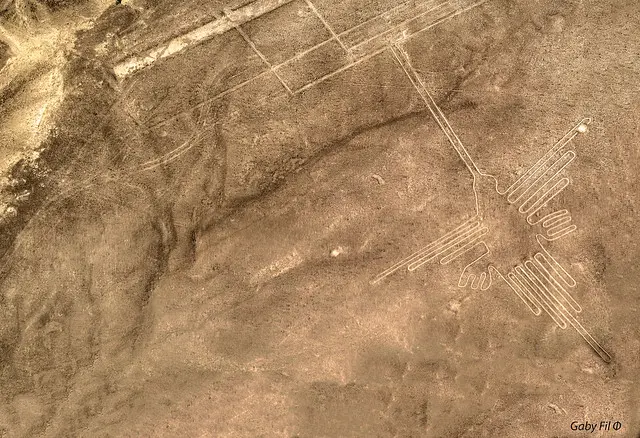
What makes the Nazca Lines so mysterious isn’t just their size or beauty. It’s that no one fully agrees on their purpose. Some theories say they were ritual walkways. Others claim they were linked to astronomy. A few believe they were communication symbols meant for beings in the sky.
The dry, windless desert has preserved the lines for over 2,000 years. Walk nearby and they seem like shallow grooves. Fly above them, and the full designs suddenly snap into view. That shift—from invisible to massive—adds to the surreal experience.
Today, small aircraft take visitors above the lines on quick flights. You’ll circle the key figures as the pilot dips from side to side, giving every seat a clear look. It’s dizzying, it’s ancient, and no one can fully explain why they’re there.
2. The Door to Hell
Location: Derweze, Ahal Province, Turkmenistan
How to get there:
Fly into Ashgabat International Airport. From there, drive approximately 160 miles north into the Karakum Desert. Private 4x4 tours are the most reliable option.
In the middle of the Karakum Desert, there's a pit that burns day and night. Locals call it the Door to Hell. It’s a crater 230 feet wide, glowing with flames that never stop flickering. The heat can be felt from the rim. The air smells faintly of sulfur. Stand too close, and the fire seems to breathe.
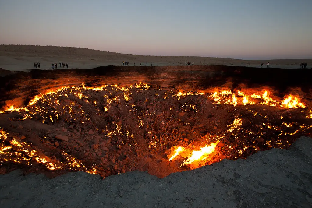
This wasn’t caused by nature. In 1971, Soviet engineers were drilling for natural gas. The ground collapsed under their rig, forming the massive hole. Fearing a gas leak, they lit it on fire to burn off the methane. That was over 50 years ago. The fire never went out.
Despite the name, it’s oddly beautiful—especially at night. The crater glows orange against the dark desert, like a giant coal pit dropped from the sky. It doesn’t hiss or roar. It just burns, steady and quiet.
There are no barriers, no signs, no entrance fees. Just a dirt path leading to a fiery pit in the middle of nowhere. Travelers who make the journey usually camp nearby to see it both at sunset and sunrise. It’s one of the few places on Earth where you can stare into a literal burning hole and realize no one really knows how to turn it off.
3. Island of the Dolls
Location: Xochimilco, Teshuilo Lake, Mexico City, Mexico
How to get there:
Fly into Mexico City International Airport. Take a taxi or metro to the Xochimilco docks, then board a traditional trajinera boat. The island is about a 2-hour float through the canals.
Just south of Mexico City, deep within the canals of Xochimilco, there’s an island that makes even the most seasoned travelers uneasy. Trees hang heavy with old dolls—broken, dirty, and missing limbs. Some have no eyes. Others stare blankly through cracked faces. Locals call it Isla de las Muñecas, or the Island of the Dolls.
The story begins with a man named Don Julián Santana. In the 1950s, he moved to this small patch of land. Not long after, he claimed to find the body of a drowned girl in the water nearby. Soon after, he saw a doll floating in the canal. He hung it in a tree to honor her spirit. Then more dolls appeared. One by one, he collected them—some from the water, others from trash piles. He hung them all, believing they kept the girl's spirit calm.

Don Julián lived alone among these dolls for decades. Some say he spoke to them. Some say they spoke back. In a strange twist, he died in the same spot where he claimed to find the girl.
Visitors today arrive by boat. The silence builds. Then the trees come into view, each one heavy with weather-beaten dolls. It’s unsettling, but you won’t look away.
4. Lake Natron
Location: Northern Tanzania, near the Kenya border, Arusha Region
How to get there:
Fly into Kilimanjaro International Airport. From there, drive approximately 7 hours north toward the Ngare Sero area using a 4x4 vehicle. Guided tours are recommended due to remote access.
Lake Natron is bright red, smells of sulfur, and looks like it belongs on another planet. Located in northern Tanzania, this shallow salt lake isn’t known for relaxing swims. Instead, it has a deadly reputation. Its water is so alkaline, it can burn skin. The pH levels often climb higher than ammonia. But the strangest part? It seems to turn animals into stone.
Birds and bats that die in or near the lake calcify in the intense environment. Their bodies dry quickly and become hard, almost statue-like. Photographer Nick Brandt once captured images of these creatures, preserved in eerie perfection. The effect isn’t magical—it’s chemistry. The lake’s mix of sodium carbonate and heat mummifies bodies instead of allowing decay.
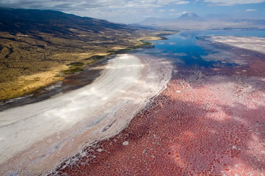
Despite the harsh conditions, thousands of flamingos choose Lake Natron as a breeding ground. The lake’s harshness keeps predators away. Its warmth helps incubate their eggs. It’s one of the only places in the world where this particular species nests.
The lake shifts color depending on light and algae growth—ranging from blood-red to bright orange. It’s stunning from a distance, dangerous up close, and entirely real. Few places combine beauty and danger like this one.
5. Aokigahara Forest
Location: Base of Mount Fuji, Yamanashi Prefecture, Japan
How to get there:
Fly into Tokyo’s Haneda or Narita Airport. Take a train to Kawaguchiko Station (about 2.5 hours), then a 30-minute bus ride to the Aokigahara entrance.
Aokigahara Forest looks peaceful at first. Thick green trees, winding paths, and Mount Fuji rising in the distance. But step inside, and the mood shifts fast. Sound fades. Birds are rare. Even your footsteps seem to vanish into the moss. Locals call it the Sea of Trees. Travelers know it by another name: the Suicide Forest.
The forest sits on hardened lava from an eruption over 1,000 years ago. That lava absorbs sound. As you walk, there’s a sense of vacuum-like silence. It’s not haunted in the way horror movies show, but it does feel heavy, like the woods are holding their breath.

Aokigahara has become a focal point of folklore and tragedy. For decades, it’s drawn people in who never planned to leave. Signs at the entrance now urge visitors to think of loved ones and call for help. Authorities patrol the area. Trails are marked, but only loosely. Some visitors wander off-path and get lost in the density.
Still, it attracts hikers, photographers, and curious travelers. The forest is beautiful. It's also deeply uncomfortable. That combination creates a rare kind of mystery—one rooted in emotion as much as in nature.
6. The Catacombs of Paris
Location: 14th Arrondissement, Paris, France
How to get there:
Fly into Charles de Gaulle Airport. Take the RER B train to Denfert-Rochereau Station. The Catacombs entrance is across the street.
Beneath the busy cafés and sidewalks of Paris lies something far older and much darker. The Catacombs are a network of underground tunnels filled with human bones—more than six million skulls and skeletons stacked along stone walls. It’s not an exhibit. It’s real remains, lined up neatly, row after row.
This macabre ossuary was born out of necessity. In the 1700s, Paris cemeteries were so overcrowded that bodies were spilling into basements. Officials decided to move the remains underground into abandoned limestone quarries. Over the years, workers arranged bones into patterns—some in the shape of crosses, hearts, or walls built entirely of femurs.
Only a small portion is open to the public. The rest stretches for miles under the city, mostly sealed off. That hasn’t stopped urban explorers from sneaking in. Some bring maps, others leave graffiti. One even made an entire underground cinema, complete with a projector and chairs.
The legal section is well-lit and guided. You descend a spiral staircase and enter a narrow corridor where the temperature drops. Then the bones appear. It’s quiet. Cool. And strange. You can feel the weight of centuries pressing down, not just from the ceilings—but from the lives stacked along the walls.
7. Mount Roraima
Location: Pacaraima Mountains, Gran Sabana Region, Bolívar State, Venezuela
How to get there:
Fly into Simón Bolívar International Airport in Caracas. Take a domestic flight to Santa Elena de Uairén, then travel by 4x4 to the village of Paraitepui. From there, it’s a multi-day guided trek to the summit.
Mount Roraima rises like a stone fortress from the rainforest. Sheer cliffs drop straight down on all sides. The summit is flat, high, and often lost in the clouds. It feels less like a mountain and more like a giant table forgotten by the gods. Some say this is the real inspiration for Arthur Conan Doyle’s The Lost World—and once you see it, you’ll believe it.
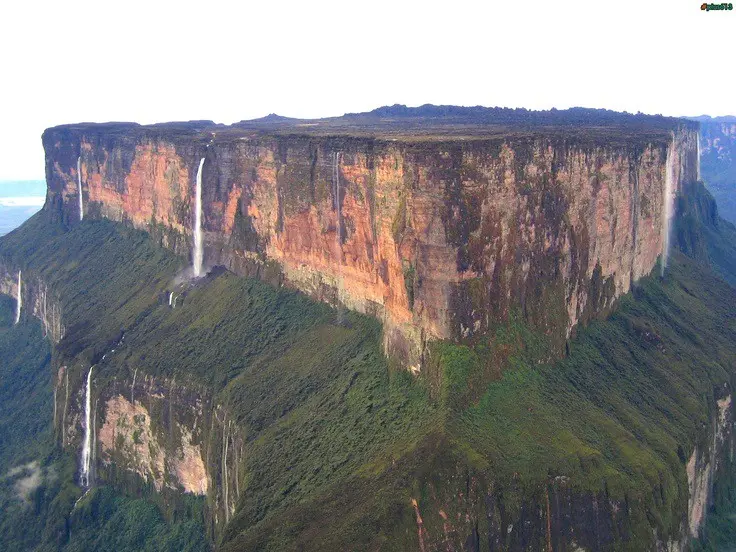
The surface of Roraima looks alien. Pools of black water sit in rock basins. Strange plants grow nowhere else on Earth. The weather changes without warning. One moment you're walking in sunlight, the next you’re surrounded by mist and rain. Even GPS struggles here due to the shifting atmosphere.
What makes it mysterious isn’t just the shape or size. It’s the isolation. The summit remained unexplored until the 1800s. Indigenous legends describe it as the stump of a mighty tree that once held all the fruits of the world. Climbing it was forbidden.
Today, it still takes effort to reach. The hike to the top lasts several days and moves through multiple ecosystems. Reaching the plateau feels like stepping into another timeline—one that forgot the rest of the world kept moving.
8. Devils Tower
Location: Crook County, Northeastern Wyoming, USA
How to get there:
Fly into Rapid City Regional Airport in South Dakota. Drive west for about 2 hours to reach Devils Tower National Monument.
Rising straight from the rolling plains of Wyoming, Devils Tower looks like something out of science fiction. Its vertical rock columns stretch 867 feet into the air, creating a towering formation unlike anything nearby. It’s easy to see why Native American tribes saw it as sacred long before it became the first U.S. national monument in 1906.
Geologists still debate exactly how it formed. Some say it’s the core of an ancient volcano. Others suggest it was pushed up from underground as molten rock cooled and cracked into the iconic hexagonal pillars. The result is a natural skyscraper, visible for miles.
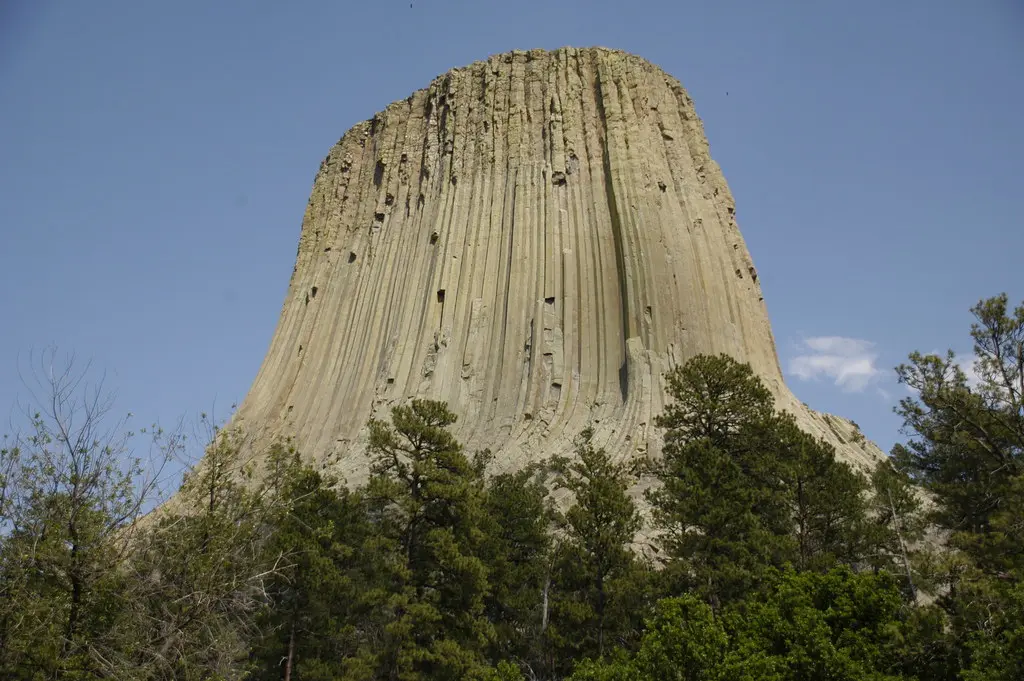
But what really sets it apart are the stories. The Lakota tell of children chased by a bear. The Great Spirit raised the ground beneath them, and the bear clawed at the sides—creating the vertical lines that still mark the tower today.
In pop culture, Devils Tower is etched into memory from Close Encounters of the Third Kind. In real life, climbers from around the world attempt the vertical routes, and visitors walk the loop trail around its base, often in silence.
9. Eternal Flame Falls
Location: Chestnut Ridge Park, Orchard Park, New York, USA
How to get there:
Fly into Buffalo Niagara International Airport. Drive 30 minutes south to Chestnut Ridge Park. The hike to the falls is about 1 mile through wooded trails.
Tucked into a quiet forest in upstate New York, there’s a small waterfall with a strange surprise. Behind the flowing water, a flame burns—real fire, fueled by natural gas leaking from deep within the Earth. It’s called Eternal Flame Falls, and it lives up to the name. The flame doesn’t go out. Even when the water spills over it.
The gas seep is caused by a crack in the shale beneath the falls. As methane escapes, it ignites, producing a flickering orange flame that dances just inches behind the curtain of water. It’s not big—usually just a few inches high—but it’s bright and unmistakable.
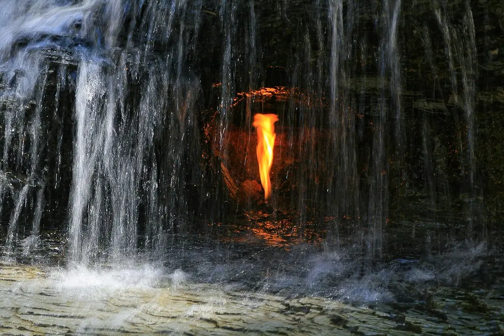
Visitors often bring lighters to relight it if wind or moisture temporarily snuffs it out. But most of the time, it burns on its own. Fire and water, side by side. No tricks. No pipes. Just geology doing something unexpected.
Getting there isn’t difficult, but the trail can be slippery, especially after rain. You’ll hear the falls before you see them. Then, as you get close, you’ll notice the glow—a flicker at the heart of a quiet stream. It feels like something that shouldn’t exist, but somehow does.
10. The Bermuda Triangle
Location: Roughly bordered by Miami (USA), San Juan (Puerto Rico), and Bermuda
How to get there:
Accessible from multiple points. Fly into Miami International Airport for the most common departure zone by sea or air.
The Bermuda Triangle has pulled ships, planes, and imaginations into its grip for decades. This patch of Atlantic Ocean—spanning around 500,000 square miles—has been blamed for countless disappearances. Entire crews vanish. Aircraft lose contact. Some are never found. Others are recovered with no sign of distress.
Theories run wild. Magnetic field shifts. Sudden storms. Rogue waves. Methane gas bubbles rising from the seafloor. Even time warps and alien abductions get tossed around. What’s confirmed is this: More than 50 ships and 20 aircraft have disappeared here since the early 1900s, many without distress calls or debris.
One of the most famous cases is Flight 19—a squadron of U.S. Navy bombers that vanished in 1945. The rescue plane sent after them also disappeared. Search teams found nothing.
Despite the legends, commercial planes and cruise ships pass through the area every day without issue. Still, the sense of unease lingers. Compasses sometimes act strangely. Weather can turn without warning. Pilots report electronic interference.
It’s not marked on maps. There’s no sign saying, “You’ve entered the Triangle.” But those who know the stories can feel it. A stretch of ocean where reason seems to lose its footing.
11. Plain of Jars
Location: Xiangkhoang Plateau, near Phonsavan, Laos
How to get there:
Fly into Wattay International Airport in Vientiane. Take a domestic flight to Phonsavan Airport. From there, it’s a short drive to the main jar sites.
Scattered across northern Laos are thousands of massive stone jars—some weighing over 10 tons. They sit in fields, clusters, and along hillsides, as if a forgotten civilization was preparing for a banquet the world never got to see. This region is called the Plain of Jars, and its origin remains one of Southeast Asia’s most intriguing mysteries.
No one knows exactly who built them, or why. The jars date back at least 2,000 years. Some believe they were used in burial rituals. Others think they were used to ferment rice wine. A few still hold charred bones and ancient tools, but no written record explains their full purpose.
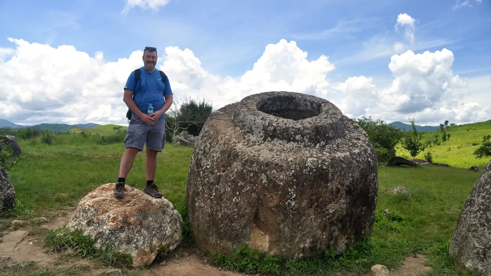
The largest site—known as Site 1—holds over 300 jars, many taller than a grown adult. They’re carved from sandstone, granite, and limestone, and no two are exactly the same. Despite centuries of weather and war, most are intact.
The area was heavily bombed during the Vietnam War, and unexploded ordnance still surrounds some jar fields. Today, cleared zones are open to tourists, with pathways marked for safety.
Standing among them feels surreal. They’re older than most written history in the region, but they were never buried, never hidden. Just left in place—massive, silent, and still unexplained.
12. Moeraki Boulders
Location: Koekohe Beach, between Moeraki and Hampden, South Island, New Zealand
How to get there:
Fly into Dunedin Airport. Drive north along State Highway 1 for about 1 hour to reach Koekohe Beach.
Lined up along a remote stretch of sand on New Zealand’s South Island are dozens of massive, perfectly round stones. Some are as big as cars. Others are cracked open like ancient eggs, revealing hollow centers lined with crystals. These are the Moeraki Boulders, and they look like they’ve been placed there for a reason—but nature is the only artist at work.
Formed over 60 million years ago, these boulders are concretions: balls of sediment slowly hardened over time, layer by layer. What makes them strange isn’t just their shape—it’s their isolation. They appear suddenly on the beach, sitting apart from any visible rock formation, like the leftovers from a giant’s forgotten game.
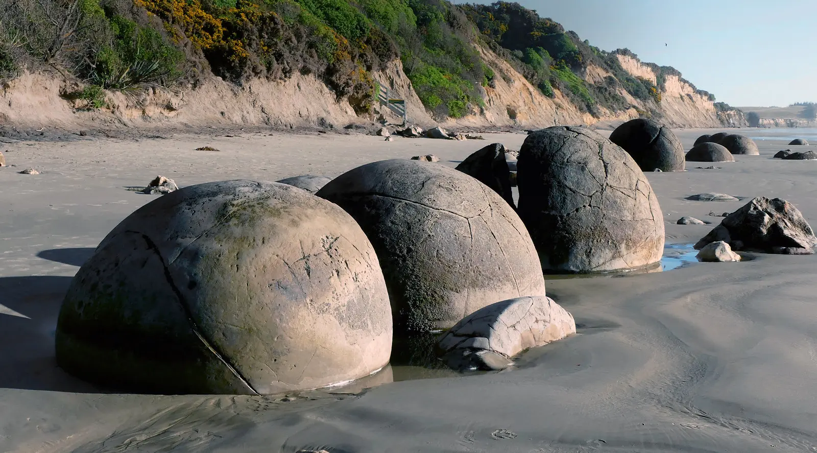
Some are nearly six feet wide and weigh several tons. Māori legend says they are the remains of food baskets and calabashes that washed ashore after a legendary canoe wrecked nearby. That story has lasted for generations, and it's easy to believe when you see them in person.
Visitors walk among the boulders at low tide. Some pose next to them, others climb on top. Most just stare. The symmetry is unnatural, yet the science behind them is solid. It’s the kind of mystery where geology and mythology quietly agree.
13. Socotra Island
Location: Socotra Archipelago, off the coast of Yemen, Arabian Sea
How to get there:
Fly into Cairo or Abu Dhabi. From there, take a connecting charter flight to Socotra Airport (usually via Seiyun, Yemen). Travel is limited and often seasonal.
Socotra Island doesn’t look real. Its trees have thick trunks and umbrella-shaped tops that drip red sap. Its deserts bloom with plants found nowhere else on the planet. Even its coastline has caves carved into limestone cliffs that seem more like movie sets than landscapes. Biologists call it the “Galápagos of the Indian Ocean.” One look, and you’ll understand why.
Over a third of Socotra’s plant life is endemic. The Dragon’s Blood Tree, with its tentacle-like branches and crimson resin, is the icon of the island. Bottle trees look swollen and strange, like cartoon drawings. The air smells of frankincense and sea salt. Everything feels ancient, untouched.
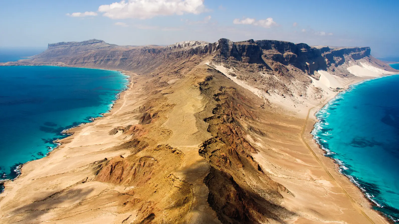
The island split from mainland Africa millions of years ago, giving species time to evolve in isolation. That’s why its biodiversity feels alien. But the real mystery is how little has changed. Despite modern pressures, Socotra has managed to preserve its ecosystems with almost no outside interference.
Tourism here is tightly controlled. There are no large hotels, no chain restaurants. Visitors camp under the stars or stay in simple homestays. The silence, the light, the shapes—it’s all wildly unfamiliar in the best way possible.
14. The Underwater City of Shi Cheng
Location: Qiandao Lake, Zhejiang Province, China
How to get there:
Fly into Hangzhou Xiaoshan International Airport. From there, it’s about a 2-hour drive to Qiandao Lake. Diving tours leave from nearby dock towns like Chun’an.
Deep beneath the surface of Qiandao Lake lies a city no one expected to visit again. Shi Cheng—also known as Lion City—was built during the Eastern Han Dynasty over 1,300 years ago. For centuries, it stood as a cultural and political hub. Then in the 1950s, it was purposely flooded during the construction of a hydroelectric dam. The city was lost to the lake, and for decades, it stayed forgotten.
In the early 2000s, divers exploring the lakebed discovered something shocking: the entire city was still intact. Temples, stone roads, wooden beams, even carvings on the archways had been preserved by the cold, still water. It wasn’t ruins—it was a time capsule.
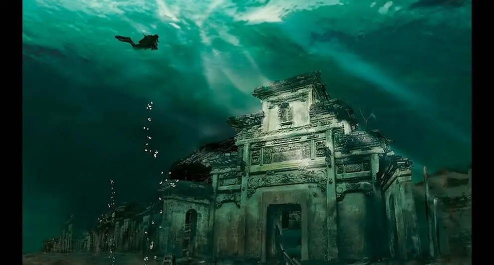
Shi Cheng sits at depths between 85 and 130 feet. Due to low oxygen and minimal currents, the structures have suffered little erosion. Some walls still bear original paint. Doorways stand open. It feels like the people just left.
Now, guided dives take visitors through submerged alleys and past ancient rooftops. For those who don’t dive, drone and submarine footage offers a glimpse of this ghost city. It’s not myth or legend—it’s history, hidden in plain sight.
15. Magnetic Hill
Location: Near Leh, Ladakh region, northern India
How to get there:
Fly into Kushok Bakula Rimpochee Airport in Leh. From there, drive about 30 minutes west on the Leh–Kargil–Baltic National Highway.
On a quiet highway cutting through the Himalayan desert, there's a stretch of road that plays with perception. Stop your car at the white marker, shift into neutral, and wait. Slowly, the vehicle begins to roll uphill—on its own. It feels like magic, but the locals call it Magnetic Hill.
The name suggests magnetic force, but that’s not quite it. What’s happening here is an optical illusion. The layout of the surrounding landscape tricks your brain into seeing a downhill slope as an uphill one. The hills rise and fall in just the right way to warp your depth perception. Your eyes say it’s uphill. Physics says otherwise.
Tourists stop here year-round. Some swear their phones act up. Others claim compasses spin. Drivers test the slope over and over again, and reactions are always the same—confused laughter, then disbelief.
There are road signs pointing to the exact spot, and most tours include it as a highlight. The backdrop is stark and beautiful—tan hills, open sky, and that one stretch of road where things don’t add up.
16. Crooked Forest
Location: Outside Gryfino, West Pomeranian Voivodeship, Poland
How to get there:
Fly into Szczecin-Goleniów Airport. Drive about 1 hour south to the small village of Nowe Czarnowo near Gryfino.
In a forest just beyond the Polish town of Gryfino, 400 pine trees stand in eerie formation. Each one bends sharply at the base before growing straight again, creating a consistent J-shape as if a powerful wind once froze them mid-motion. They are tall, healthy, and identical in their strange curve. Locals call it the Crooked Forest.
Planted in the 1930s, these pines were likely altered when they were young saplings. But no one knows how—or why. Some believe farmers manipulated them intentionally to grow curved wood for shipbuilding or furniture. Others suggest war or natural disaster bent them by force. There’s no definitive answer. What’s clear is that it only happened here. Trees in the surrounding forest stand tall and straight.
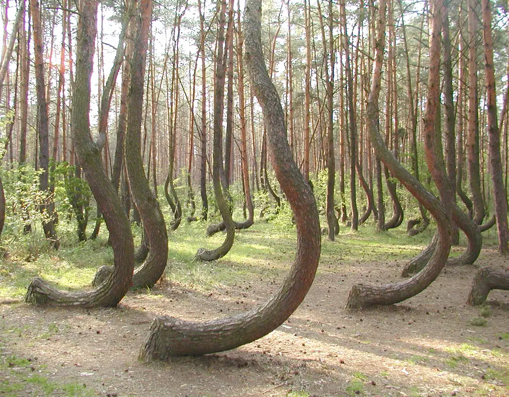
Walking through the site feels surreal. The trunks curve with mathematical consistency, but the pattern seems more artistic than functional. The area is open to visitors, though signage is minimal and the site remains quiet, without commercial tourism or fanfare.
Time and science may one day explain the curves. For now, the forest remains a quiet anomaly—an accidental sculpture garden shaped by human hands or nature’s mischief.
17. Yonaguni Monument
Location: Off the coast of Yonaguni Island, Yaeyama Islands, Okinawa Prefecture, Japan
How to get there:
Fly into Naha Airport on Okinawa’s main island. Then take a connecting flight to Yonaguni Airport. Dive tours depart from the island’s main marina.
Just below the surface of the East China Sea, divers discovered something unexpected—massive stone formations with flat terraces, straight edges, and sharp corners. The site is now known as the Yonaguni Monument. Some believe it’s an underwater city. Others say it’s nothing more than a natural rock formation. But one thing is certain: it looks built.
The structure stretches over 300 feet in length and includes what appear to be steps, pillars, and platforms. Some parts resemble temples. Others look like wide roads. The angles are precise. The symmetry is unsettling.
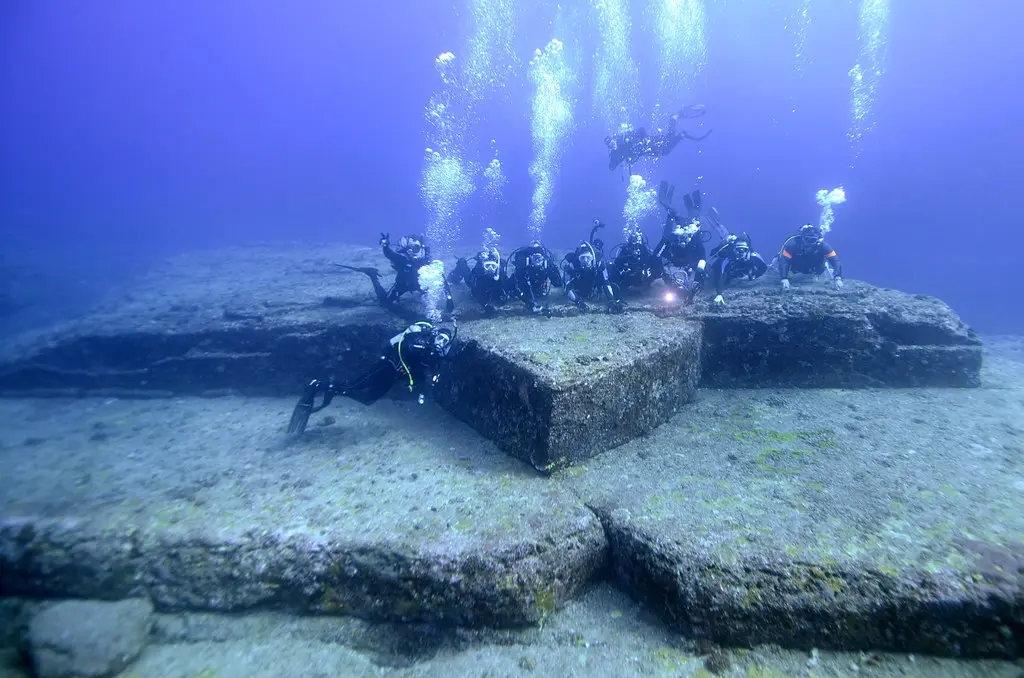
Japanese diver Kihachiro Aratake stumbled upon the site in 1986 while searching for hammerhead sharks. He wasn’t expecting to find what looked like sunken ruins. Since then, the area has drawn marine archaeologists, conspiracy theorists, and curious travelers from around the world.
There’s no clear evidence of tool marks or carvings, and skeptics argue erosion caused the geometric shapes. Still, certain parts of the monument don’t align with known natural formations in the region. Some even claim it predates the Ice Age, submerged when sea levels rose.
18. Wulingyuan Scenic Area
Location: Zhangjiajie, Hunan Province, China
How to get there:
Fly into Zhangjiajie Hehua International Airport. From there, it’s a 40-minute drive to the main entrance of Wulingyuan.
In central China’s Hunan Province, jagged stone towers rise straight out of the forest like a natural skyline. Some stretch hundreds of feet into the air. Mist curls around their bases. Vines cling to their sides. These quartz-sandstone pillars make up the Wulingyuan Scenic Area—over 3,000 vertical rock spires packed into one surreal destination.
It’s not hard to see why James Cameron used this place as inspiration for Avatar. The mountains feel like they could float. The most famous peak, once called the Southern Sky Column, was renamed “Avatar Hallelujah Mountain” after the movie's release.
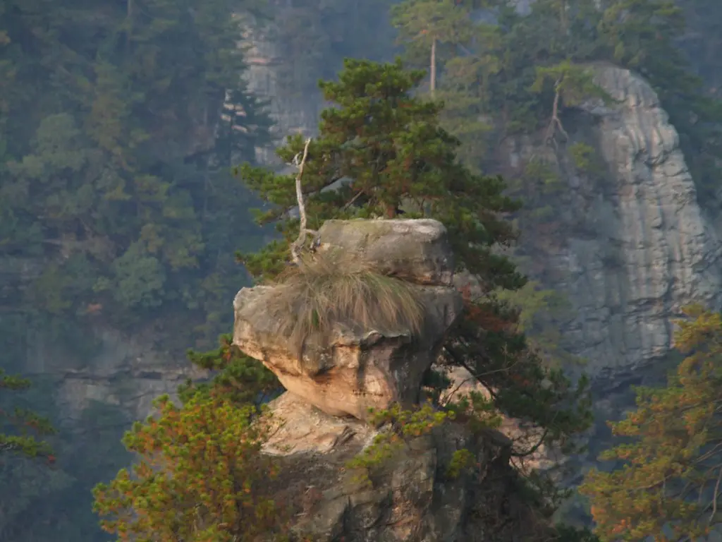
The landscape was formed by millions of years of erosion. Rain and frost carved narrow gorges and deep ravines, leaving behind towering columns that seem to defy gravity. Some are so tall and thin, it’s hard to believe they haven’t tipped over.
Cable cars, glass walkways, and trails wind through the area, giving travelers a front-row view of this stone jungle. But even with modern access, Wulingyuan still feels like another world—quiet, towering, and ancient.
It’s one of China’s most striking tourist attractions, yet parts of it still feel untouched. A place where the planet’s raw creativity is fully on display.
19. Jeju Island Lava Tubes
Location: Jeju Island, off the southern coast of South Korea
How to get there:
Fly into Jeju International Airport. From there, drive or take a local bus about 45 minutes northeast to the Manjanggul Lava Tube entrance.
Beneath the volcanic landscape of Jeju Island lies a vast labyrinth sculpted not by hands, but by flowing lava. The island is covered with these underground tubes—long, winding tunnels created when molten lava rushed beneath the surface thousands of years ago. The most famous of these is Manjanggul, one of the largest and best-preserved lava tubes in the world.
Walking through it feels like entering a secret the Earth tried to keep hidden. The tunnel stretches over eight miles, though only about half a mile is open to visitors. Inside, the air is cool and still. The walls shimmer with mineral deposits, and strange rock formations rise like frozen waves from the floor.
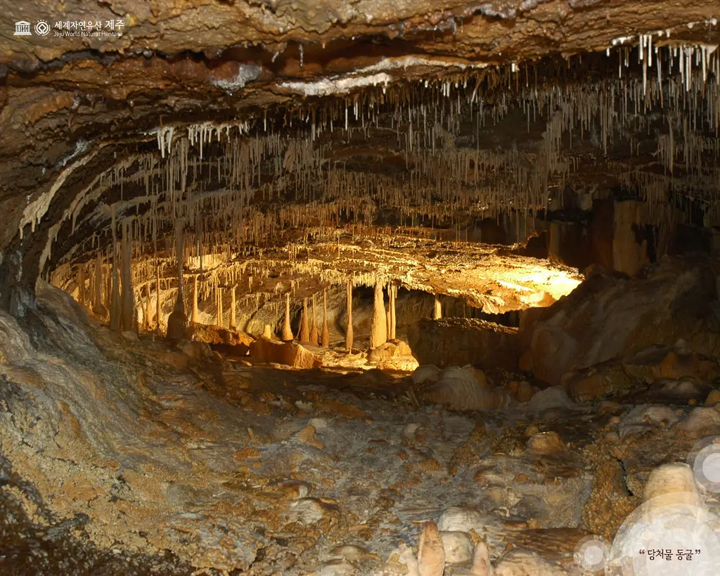
One standout feature is a massive lava column—the tallest of its kind—formed as molten rock fell from the ceiling and hardened mid-drip. It looks like a stone waterfall caught in time.
Unlike caves carved by water, these tubes are smooth, structured, and oddly geometric. Their scale feels engineered, but it’s all volcanic design. Jeju’s lava tubes aren’t just geologic features—they’re works of natural architecture.
Today, they form part of a UNESCO World Heritage site, making them a key highlight on travel sites and a must-see for visitors exploring South Korea.
Conclusion
Across continents and oceans, the world is still full of places that resist easy answers. From fires that burn in silence to trees that grow in identical curves, these 19 destinations show that mystery isn’t something we outgrow—it’s something we seek out.
What makes these places fascinating isn’t just what they are, but how they make you feel. You stand before a crater, or step into a lava tunnel, and suddenly the rules seem different. The scale shifts. The senses go quiet. And for a moment, you’re reminded that the planet doesn’t always move in straight lines or follow explanations.
Some of these sites were formed by nature. Others carry the weight of forgotten rituals or unfinished stories. But all of them challenge routine thinking. They ask questions without offering easy answers.
You won’t leave these places with full understanding. That’s the point. The best destinations don’t hand you everything—they give you something to carry back, something to puzzle over long after the trip is done.
So go. Visit the strange, the quiet, the difficult-to-explain. Explore with respect, ask better questions, and let the unknown sharpen your curiosity.
Mystery isn’t a barrier. It’s an invitation.
FAQs Section
1. What is Devils Tower National Monument known for?
Devils Tower is known for its striking column-like shape and cultural importance. It rises dramatically from the Wyoming plains and holds deep spiritual significance for Native American tribes. It was also the first U.S. national monument and gained pop culture fame from Close Encounters of the Third Kind. The tower attracts climbers, hikers, and those fascinated by its mysterious geologic formation.
2. How far is Mexico City from the Island of the Dolls?
The Island of the Dolls is located about 17 miles south of central Mexico City, in the Xochimilco canals. Visitors usually travel by car or metro to the Embarcadero Cuemanco docks, then board a trajinera boat. The round-trip journey through the canals takes around two hours, offering eerie views of trees filled with weathered, decaying dolls tied to branches.
3. Is Jeju Island worth visiting?
Yes, Jeju Island is worth visiting for its volcanic landscapes, lava tubes, waterfalls, and coastal cliffs. It’s a UNESCO-listed site with outdoor adventures, local markets, and unique culture. The Manjanggul Lava Tube alone draws thousands each year, and the island is also known for its food, beaches, and stone statues. It’s one of South Korea’s top-rated natural travel destinations.
4. What’s the best time to visit the Nazca Lines?
The best time to visit the Nazca Lines is between May and October. During this dry season, skies are clearer, winds are calmer, and visibility from small aircraft is at its best. Flights over the lines depart daily, and morning hours offer the smoothest conditions for viewing these massive geoglyphs carved into Peru’s desert floor.
5. What’s the weather like at Lake Natron?
Lake Natron’s climate is hot and dry, with temperatures often reaching 40°C (104°F) during the day. The area sees little rainfall, especially from June to October, which is also flamingo nesting season. The lake’s extreme alkalinity and high salt content make it one of the harshest environments in East Africa, yet it still supports unique wildlife and surreal landscapes.
6. What are the top tourist places in South America with mysteries?
South America is home to several mysterious sites. Top picks include the Nazca Lines in Peru, Tiwanaku in Bolivia, and Easter Island (politically part of Chile). Each features unexplained architecture or symbols tied to ancient civilizations. These locations continue to spark debate among researchers and remain major tourist attractions for those drawn to historical riddles and prehistoric engineering.